Related Article
-
Hokkaido zoo’s popular “animal gift envelopes” use ancient Japanese art of mizuhiki cordwork
-

[Report] Cute edible bears take a bath in a delicious Japanese hot pot!
-
Majestic Frost Flowers Cover Entire Lake In Snowy Hokkaido
-
Adventure through Hokkaido’s ‘Hell Valley’ after dark with this unique hotel package
-

Surprise party of Hokkaido wildlife gives Twitter user a memorable bar hopping encounter
-

Birds Clash In A Squeaky Rap Battle…Or Chirpy Political Debate


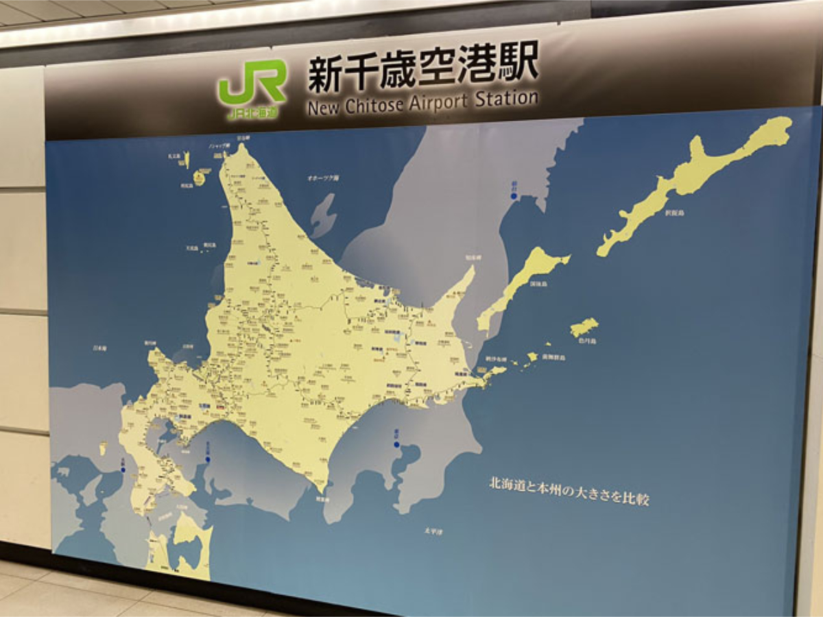
Aside from the island of Honshu, Hokkaido is Japan’s largest area of landmass, and is by far the biggest prefecture in the country. Despite having a size of 83,424 ㎢; which is at least five times the size of Honshu’s largest prefecture of Iwate (15, 275㎢), many people still struggle to believe in it’s vast expanse.
Drawing attention to the fact, Hokkaido’s New Chitose Airport proudly boasts a map showing the true scale of the island. This map happened to catch the eye of traveller, Saizonoji (a youtuber who shares videos based on themes of railway), as he was passing through the airport, and left him feeling overwhelmed by Hokkaido’s immensity.
Source: Source: @SAIONJI_com
What the airport actually did to show off the island’s dimensions, was to place a map of Hokkaido over one of Honshu. When laid over the main island of Japan, the overwhelming scale of Hokkaido can be seen, with it reaching further than the Kanto region in the east and Kansai in the west, and completely covering the whole area of Hokuriku.
It wasn’t just Saizonoji who was surprised by the size comparison, as many took to his twitter post with exclamations of astonishment:
“Hokkaido has a strange sense of distance and size – even from the perspective of a former Hokkaido citizen” @knight__x1440
“It’s really much bigger than I thought!” @r0y2o1t8a
“The distance between Sapporo and Kushiro is the same as that between Tokyo and Nagoya!” @yamachan_7024
People often make the mistake of believing travel between Hakodate and Sapporo must be easy because they are located on the same island, but in reality, they are separated by around 300km of land, which takes roughly 4 hours to drive by car.
As you can imagine, with a size this large, it isn’t exactly easy to move around Hokkaido, and any travel within the prefecture should be well-thought-about in advance to consider the amount of time and distance that will be needed to be covered.
And for readers outside of Japan who are yet to visit or are unaware of what the true size of Japan is like, for reference, Japan is roughly 377,975㎢, which is just slightly smaller in size compared to the state of California which numbers at around 403,882㎢.
Compare it to the United Kingdom (which is approximately 242,500㎢), and Japan is around 64% bigger – this, I know from experience has been hard for my fellow Brits to take in, as the Mercator map we grew up with wrongly depicts the sizing, and peters map – although more accurate – still distorts the shapes of land.
For a fun way to roughly compare the sizes of countries, check out this website, and see how your country looks when placed next to others.